L'automazione del censimento tecnologico. Il centro storico di Betlemme
DOI:
https://doi.org/10.19229/2464-9309/12162022Parole chiave:
fotogrammetria, Betlemme, monitoraggio urbano, riconoscimento di oggetti, censimento architettonicoAbstract
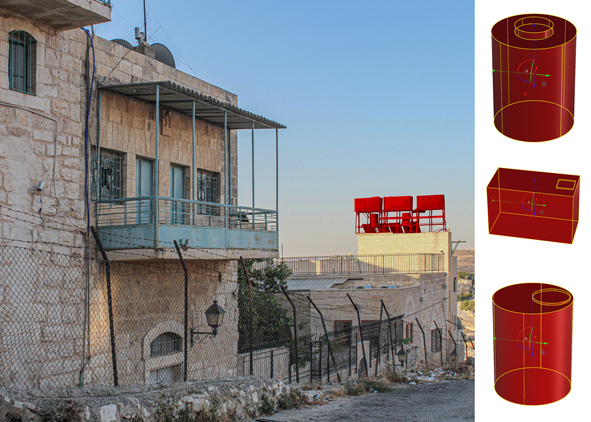
Il contributo riporta gli esiti di una ricerca sull’automazione del censimento di elementi tecnologici in ambito urbano a supporto della progettazione di un sistema di gestione e monitoraggio del Patrimonio architettonico. Lo studio si interessa di alcuni particolari elementi (i serbatoi idrici) presenti sulle coperture del centro storico di Betlemme e utilizza acquisizioni fotogrammetriche close-range come base di addestramento di modelli di Deep Learning. Il ciclo di vita dei modelli di Deep Learning, dalla fase di addestramento fino alla restituzione degli output e l’archiviazione di immagini e metadati è effettuato sfruttando la scalabilità di un’infrastruttura cloud. Il monitoraggio con ispezioni periodiche permette di confrontare condizioni differenti e valutare situazioni di criticità rilevando variazioni quali sostituzione, aggiunta e rimozione degli elementi ricercati. Il progetto ha l’obiettivo di definire un protocollo per automatizzare l’identificazione di elementi ricorrenti e monitorarli nel tempo.
Downloads
##plugins.generic.articleMetricsGraph.articlePageHeading##
Riferimenti bibliografici
Abueladas, A.-R. A., Niemi. T. M., Al-Zoubi, A., Tibor, G., Kanari, M. and Ben-Avraham, Z. (2021), “Liquefaction susceptibility maps for the Aqaba-Elat region with projections of future hazards with sea-level rise”, in Quarterly Journal of Engineering Geology and Hydrogeology, vol. 54, issue 2, pp. 1-12. [Online] Available at: lyellcollection.org/doi/10.1144/qjegh2020-039 [Accessed 30 September 2022].
Bocconcino, M. M. and Manzone, F. (2019), “Sistemi informativi e strumenti grafici per la manutenzione di manufatti complessi | Information systems and graphic tools for the maintenance of complex buildings”, in Garda, E., Mele, C. and Piantanida, P. (eds), Colloqui.AT.e 2019 – Ingegno e costruzione nell’epoca della complessità – Atti del Convegno – Torino, 25-28 Settembre 2019, Edizioni Politecnico di Torino, Torino, pp. 678-688. [Online] Available at: researchgate.net/publication/348334768_Sistemi_informativi_e_strumenti_ grafici_per_la_manutenzione_di_manufatti_complessi_-_Information_systems_and_graphic_tools_for_the_maintenance_of_complex_ buildings [Accessed 30 September 2022].
Buratti, G., Conte, S. and Rossi, M. (2021), “Artificial Intelligency, Big Data and Cultural Heritage”, in Giordano, A., Russo, M. and Spallone, R. (eds), Representation challenges – Augmented Reality and Artificial Intelligence in Cultural Heritage and Innovative Design Domain, FrancoAngeli, Milano, pp. 29-33. [Online] Available at: re.public.polimi.it/retrieve/e0c31c11-a30c-4599-e053-1705fe0aef77/Buratti_Conte_Rossi.pdf [Accessed 30 September 2022].
Carbone, C., Fawakherji, M., Trianni, V. and Nardi, D. (2022), “Photorealistic simulations of crop fields for remote Sensing with UAV swarms”, in Parrinello, S., Barba, S., Dell’Amico, A. and di Filippo, A. (eds), D-SITE. Drones – Systems of Information on Cultural Heritage for a spatial and social investigation, Pavia University Press, Pavia, pp. 576-581. [Online] Available at: paviauniversitypress.it/catalogo/d-site/6693 [Accessed 12 October 2022].
Corea, F. (2019), An Introduction to Data – Studies in Big Data, vol. 50, Springer, Cham. [Online] Available at: doi.org/10.1007/978-3-030-04468-8 [Accessed 30 September 2022].
Ćosović, M. and Janković, R. (2020), “CNN Classification of the Cultural Heritage Images”, in 2020 19th International Symposium INFOTEH-JAHORINA (INFOTEH), IEEE, pp. 1-6. [Online] Available at: doi.org/10.1109/INFOTEH48170.2020.9066300 [Accessed 30 September 2022].
Cunha, H. S., Sclauser, B. S., Wildemberg, P. F., Fernandes, E. A. M., dos Santos, J. A., de Oliveira Lage, M., Lorenz, C., Barbosa, G. L., Quintanilha, J. A. and Chiaravalloti-Neto, F. (2021), “Water tank and swimming pool detection based on remote sensing and deep learning – Relationship with socioeconomic level and applications in dengue control”, in PLoS ONE, vol. 16, issue 12, pp. 1-24. [Online] Available at: doi.org/10.1371/journal.pone.0258681 [Accessed 12 October 2022].
Dabdoub Nasser, C. and Ḥifẓ al-Turāth al-Thaqāfī, M. (2005), Anatreh Quarter – An Urban and Architectural Study of a Bethlehem Quarter, Centre for Cultural Heritage Preservation, Bethlehem.
Dandabathula, G. B., Saini, S., Parikh, D., Sharma, P., Khandelwal, S. and Rao, S. S. (2019), “Automatic detection of overhead water tanks from satellite images using faster-RCNN”, in International Journal of Advanced Research in Computer Science, vol. 10, n. 5, pp. 34-37. [Online] Available at: dx.doi.org/10.26483/ijarcs.v10i5.6466 [Accessed 12 October 2022].
De Marco, R. (2022), “Dal modello informativo ad un repository sulla stabilità delle strutture urbane – Una riflessione sulla valutazione della sicurezza negli aggregati storici della città | From the information model to a repository on the stability of urban structures – A reflection on the evaluation of safety in the historical aggregates of the city”, in Parrinello, S. (ed.), 3D Bethlehem – Gestione e controllo della crescita urbana per lo sviluppo del patrimonio e miglioramento della vita nella città di Betlemme | Management and control of urban growth for the development of heritage and improvement of life in the city of Bethlehem, vol. 3, Edifir Edizioni, Firenze, pp. 203-224. [Online] Available at: researchgate.net/publication/361305496_Dal_modello_informativo_ad_un_ repository_sulla_stabilita_delle_strutture_urbane_Una_riflessione_sulla_ valutazione_della_sicurezza_negli_aggregati_storici_della_citta_From_the_ information_model_to_a_re [Accessed 30 September 2022].
Doria, E. (2022), “Strategie di strutturazione della conoscenza – Innovazioni e attività programmabili tramite il censimento tecnologico del centro storico di Betlemme | Knowledge structuring strategies – Innovations and programmable activities via the technological census of the historic center of Bethlehem”, in Parrinello, S. (ed.), 3D Bethlehem – Gestione e controllo della crescita urbana per lo sviluppo del patrimonio e miglioramento della vita nella città di Betlemme | Management and control of urban growth for the development of heritage and improvement of life in the city of Bethlehem, vol. 3, Edifir Edizioni, Firenze, pp. 51-67. [Online] Available at: researchgate.net/publication/361217094_Strategie_di_strutturazione_della_ conoscenza_innovazioni_e_attivita_programmabili_tramite_il_censimento_ tecnologico_del_centro_storico_di_Betlemme_Knowledge_structuring_ strategies _innovations_and_prog [Accessed 30 September 2022].
Due Trier, Ø., Reksten, J. H. and Løseth, K. (2021), “Automated mapping of cultural heritage in Norway from airborne lidar data using faster R-CNN”, in International Journal of Applied Earth Observation and Geoinformation, vol. 95, article 102241, pp. 1-19. [Online] Available at: doi.org/10.1016/j.jag.2020.102241 [Accessed 12 October 2022].
Gasparoli, P. (2012), “La manutenzione preventiva e programmata del patrimonio storico tutelato come prima forma di valorizzazione | Planned preventive maintenance in the preservation of historic heritage sites as a first form of valorisation”, in Techne | Journal of Technology for Architecture and Environment, vol. 03, pp. 148-157. [Online] Available at: doi.org/10.13128/Techne-10840 [Accessed 30 September 2022].
Hatir, M. E. and İnce, I. (2021), “Lithology mapping of stone heritage via state-of-the-art computer vision”, in Journal of Building Engineering, vol. 34, article 101921, pp. 1-12. [Online] Available at: doi.org/10.1016/j.jobe.2020.101921 [Accessed 12 October 2022].
He, X., Zhao, K. and Chu, X. (2021), “AutoML – A survey of the state-of-the-art”, in Knowledge-Based Systems, vol. 212, article 106622, pp. 1-27. [Online] Available at: doi.org/10.1016/j.knosys.2020.106622 [Accessed 30 September 2022].
Kouziokas, G. N. and Perakis, K. (2017), “Decision Support System Based on Artificial Intelligence, GIS and Remote Sensing for Sustainable Public and Judicial Management”, in European Journal of Sustainable Development, vol. 6, issue 3, pp. 397-404. [Online] Available at: doi.org/10.14207/ejsd.2017.v6n3p397 [Accessed 30 September 2022].
Lakshmanan, V. (2022), Data Science on the Google Cloud Platform, Editions O’Reilly, Paris.
Lecun, Y. and Bengio, Y. (1998), “Convolutional networks for Images, Speech, and Time-Series”, in Arbib, M. A. (ed.), The Handbook of Brain Theory and Neural Networks, MIT Press, pp. 255-258.
Li, K., Wan, G., Cheng, G., Meng, L. and Han, J. (2020), “Object detection in optical remote sensing images – A survey and a new benchmark”, in ISPRS Journal of Photogrammetry and Remote Sensing, vol. 159, pp. 296-307. [Online] Available at: doi.org/10.1016/j.isprsjprs.2019.11.023 [Accessed 12 October 2022].
Majchrowska, S., Mikołajczyk, A., Ferlin, M., Klawikowska, Z., Plantykow, M. A., Kwasigroch, A. and Majek, K. (2022), “Deep learning-based waste detection in natural and urban environments”, in Waste Management, vol. 138, pp. 274-284. [Online] Available at: doi.org/10.1016/j.wasman.2021.12.001 [Accessed 12 October 2022].
McCarthy, J. (2007), What is Artificial Intelligence?, Standford University, Standford, pp. 1-15. [Online] Available at: jmc.stanford.edu/articles/whatisai/whatisai.pdf [Accessed 30 September 2022].
Miceli, A., Morandotti, M. and Parrinello, S. (2020), “3D survey and semantic analysis for the documentation of built heritage – The case study of Palazzo Centrale of Pavia University”, in Vitruvio | International Journal of Architecture Technology and Sustainability, vol. 5, n. 1, pp. 65-80. [Online] Available at: doi.org/10.4995/vitruvio-ijats.2020.13634 [Accessed 30 September 2022].
Mishra, M. (2021), “Machine learning techniques for structural health monitoring of heritage buildings – A state-of-the-art review and case studies”, in Journal of Cultural Heritage, vol. 47, pp. 227-245. [Online] Available at: doi.org/10.1016/j.culher.2020.09.005 [Accessed 30 September 2022].
Monna, F., Rolland, T., Denaire, A., Navarro, N., Granjon, L., Barbé, R. and Chateau-Smith, C. (2021), “Deep learning to detect built cultural heritage from satellite imagery – Spatial distribution and size of vernacular houses in Sumba, Indonesia”, in Journal of Cultural Heritage, vol. 52, pp. 171-183. [Online] Available at: doi.org/10.1016/j.culher.2021.10.004 [Accessed 12 October 2022].
Montella, M. (2009), Valore e valorizzazione del patrimonio culturale storico, Mondadori Electa, Milano.
Parrinello, S. (ed.) (2019), 3D Bethlehem – Gestione e controllo della crescita urbana per lo sviluppo del patrimonio e miglioramento della vita nella città di Betlemme | Management and control of urban growth for the development of heritage and improvement of life in the city of Bethlehem, vol. 3, Edifir Edizioni, Firenze.
Parrinello, S. and Picchio, F. (2019), “Integration and comparison of close-range SfM methodologies for the analysis and the development of the historical city center of Bethlehem”, in International Archives of the Photogrammetry, Remote Sensing and Spatial Information Science, vol. XLII-2/W9, pp. 589-595. [Online] Available at: doi.org/10.5194/isprs-archives-XLII-2-W9-589-2019 [Accessed 30 September 2022].
Picchio, F. (2020), “Acquisition protocols for UAV photogrammetric data – Comparison in methodological SfM procedures from architectural till urban scale”, in Barba, S., Dell’Amico, A., Limongello, M. and Parrinello, S. (eds), D-SITE – Drones-Systems of Information on culTural hEritage – For a spatial and social investigation, Pavia University Press, Pavia, pp. 70-79.
Picchio, F. (2019), “La fotogrammetria close range per la costituzione di modelli SfM affidabili sul sistema urbano”, in Parrinello, S. (ed.), 3D Bethlehem – Gestione e controllo della crescita urbana per lo sviluppo del patrimonio e miglioramento della vita nella città di Betlemme | Management and control of urban growth for the development of heritage and improvement of life in the city of Bethlehem, vol. 1, Edifir Edizioni, Firenze, pp. 119-138.
Redmon, J., Divvala, S., Girshick, R. and Farhadi, A. (2016), “You Only Look Once – Unified, Real-Time Object Detection”, in IEEE Conference on Computer Vision and Pattern Recognition (CVPR) – Las Vegas, NV, USA, June 27-30, 2016, IEEE Computer Society, pp. 779-788. [Online] Available at: cv-foundation.org/openaccess/content_cvpr_2016/papers/Redmon_You_Only_ Look_CVPR_2016_paper.pdf [Accessed 30 September 2022].
Rivera, J. D. D. S. (2020), “Object detection with a model trained in Google Cloud AutoML”, in Practical TensorFlow.js, Apress, Berkeley, pp. 164-184. [Online] Available at: doi.org/10.1007/978-1-4842-6273-3_7 [Accessed 30 September 2022].
Wang, X., Wang, H., Zhang, C., He, Q. and Huo, L. (2022), “A Sample Balance-Based Regression Module for Object Detection in Construction Sites”, in Applied Science, vol. 12, n. 13, article 6752, pp. 1-15. [Online] Available at: doi.org/10.3390/app12136752 [Accessed 12 October 2022].
Xiao, Y., Tian, Z., Yu, J., Zhang, Y., Liu, S., Du, S. and Lan, S. (2020), “A review of object detection based on deep learning”, in Multimedia Tools Application, vol. 79, pp. 23729-23791. [Online] Available at: doi.org/10.1007/s11042-020-08976-6 [Accessed 12 October 2022].
Zou, Z., Zhao, X., Zhao, P., Qi, F. and Wang, N. (2019), “CNN-based statistics and location estimation of missing components in routine inspection of historic buildings”, in Journal of Cultural Heritage, vol. 38, pp. 221-230. [Online] Available at: doi.org/10.1016/j.culher.2019.02.002 [Accessed 12 October 2022].
##submission.downloads##
Pubblicato
Come citare
Fascicolo
Sezione
Categorie
Licenza
Copyright (c) 2022 Elisabetta Doria

TQuesto lavoro è fornito con la licenza Creative Commons Attribuzione 4.0 Internazionale.
AGATHÓN è pubblicata sotto la licenza Creative Commons Attribution License 4.0 (CC-BY).
License scheme | Legal code
Questa licenza consente a chiunque di:
Condividere: riprodurre, distribuire, comunicare al pubblico, esporre in pubblico, rappresentare, eseguire e recitare questo materiale con qualsiasi mezzo e formato.
Modificare: remixare, trasformare il materiale e basarti su di esso per le tue opere per qualsiasi fine, anche commerciale.
Alle seguenti condizioni
Attribuzione: si deve riconoscere una menzione di paternità adeguata, fornire un link alla licenza e indicare se sono state effettuate delle modifiche; si può fare ciò in qualsiasi maniera ragionevole possibile, ma non con modalità tali da suggerire che il licenziante avalli l'utilizzatore o l'utilizzo del suo materiale.
Divieto di restrizioni aggiuntive: non si possono applicare termini legali o misure tecnologiche che impongano ad altri soggetti dei vincoli giuridici su quanto la licenza consente di fare.
Note
Non si è tenuti a rispettare i termini della licenza per quelle componenti del materiale che siano in pubblico dominio o nei casi in cui il nuovo utilizzo sia consentito da una eccezione o limitazione prevista dalla legge.
Non sono fornite garanzie. La licenza può non conferire tutte le autorizzazioni necessarie per l'utilizzo che ci si prefigge. Ad esempio, diritti di terzi come i diritti all'immagine, alla riservatezza e i diritti morali potrebbero restringere gli usi del materiale.